Original British WWII Allied Forces FGS-series Invasion Map of Norway Area – Sheets FGS/A and FGS/E Original Items
$ 250,00 $ 100,00
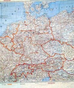
Original Items: Only One Available. This is a nice British-Made Allied forces FGS-series “invasion map”, from WWII, which is one of a series of maps, which could be spread out on a large table and interlocked. During WWII, maps needed to the constantly updated, as the frontier of the war changed over time. This map was designed to show most of Norway, in various parts, due to the shape of the country. There is a diagram on the map indicating how the various parts of the map fit together.
Sheet FGS / A shows the following regions: NORWAY (SOUTH) and SWEDEN (PART OF), while another section shows NORWAY (SOUTH), and SWEDEN (PART OF)
Sheet FGS / E shows the following regions: NORWAY (EXTREME N.E.), SWEDEN (PART OF), FINLAND (NORTH, and U.S.S.R. (MURMANSK AREA), while another section shows: GERMANY (SEA BOARD), DENMARK, and SWEDEN (SOUTH).
This example is in good condition, with great color and no tears. We cannot tell if the map is silk or rayon, as the printing on the map has stiffened it somewhat.
Ready to add to your collection and display!
More on the British FGS-Series maps:
A smaller series of cloth maps was produced at a scale of 1:1,000,000 or 1:1,250,000 depicting the Scandinavian and Northern Europe region. They were designed as a series, and also made to interface with the previous 43-Series maps.
One double-sided map is identified with as FGS A/ E and contains inserts of areas B, C, & D. Another version of A/E contains maps A through E all by inserts. Other double-sided maps in the series include A/B, C/D and E/9.C.a. FSG appears to stand for Finland Sweden Germany. The colors and specifications for this series are very similar to the 43 and 44 series mentioned above. In fact, some FGS maps expressly state they overlap with the adjoining 43/C and 43/E maps. British cloth maps were not only used by Allied aircrews during WWII but also by special operatives such as Major William E. Colby, a US officer with the Office of Strategic Services (and later a director of the Central Intelligence Agency), who carried an FGS A/E map during Mission Rype in Norway during the spring of 1945. The purpose of the operation was to sabotage railways to prevent German troops from being shifted from Norway to Germany to confront the advancing Allied troops during the latter days of the war.
Fast Shipping with Professional Packaging
Thanks to our longstanding association with UPS FedEx DHL, and other major international carriers, we are able to provide a range of shipping options. Our warehouse staff is expertly trained and will wrap your products according to our exact and precise specifications. Prior to shipping, your goods will be thoroughly examined and securely secured. We ship to thousands clients each day across multiple countries. This shows how we're dedicated to be the largest retailer on the internet. Warehouses and distribution centres can be located throughout Europe as well as the USA.
Note: Orders with more than one item will be assigned a processing date depending on the item.
Before shipping before shipping, we'll conduct a thorough inspection of the items you have ordered. Today, the majority of orders will be delivered within 48 hours. The delivery time will be between 3-7 days.
Returns
The stock is dynamic and we cannot completely manage it because multiple stakeholders are involved, including our factory and warehouse. So the actual stock may alter at any time. It's possible that you may not receive your order once the order has been made.
Our policy is valid for a period of 30 days. If you don't receive the product within 30 days, we are not able to issue a refund or an exchange.
You can only return an item if it is unused and in the same state as the day you received it. You must have the item in its original packaging.
Related products
Uncategorized
Band of Brothers ORIGINAL GERMAN WWII Le. F.H. 18 10.5cm ARTILLERY PIECE Original Items
Uncategorized
Uncategorized
Uncategorized
Uncategorized
Uncategorized
Armoured Fighting Vehicles of the World: AFVs of World War One (Hardcover Book) New Made Items
Uncategorized
Uncategorized
Uncategorized
Uncategorized
Uncategorized
Uncategorized
Uncategorized
Uncategorized
Uncategorized
Uncategorized
Uncategorized
Uncategorized
Australian WWII Owen MK1 Machine Carbine SMG Custom Fabricated Replica with Sling Original Items
Uncategorized
Angolan Rebel 1970s era 60mm Inert Display Mortar from Angolan Civil War Original Items


